
 Lisa Mariana
The United Kingdom is bracing for a significant meteorological shift as the national weather service issues comprehensive warnings for severe thunderstorms poised to impact large swathes of England and Wales this Thursday. Following a prolonged period of uncharacteristic heat and drought, these anticipated deluges are expected to bring not only substantial rainfall but also the potential for flash flooding, travel disruptions, and other hazardous conditions, marking a dramatic departure from the summer’s prevailing dry spell.
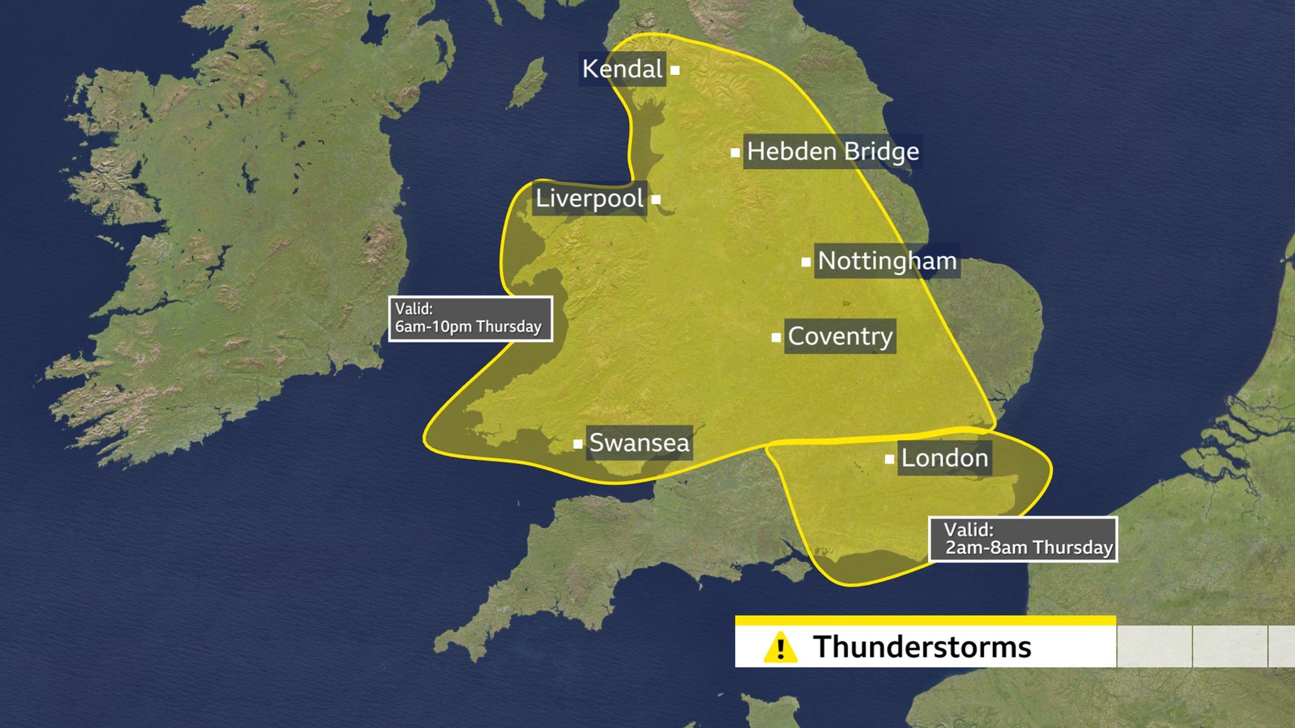
The meteorological agency has delineated a dual warning system to underscore the evolving threat. The initial alert, activating in the pre-dawn hours of Thursday, targets southeastern England, where early morning commuters can expect a rapid onset of heavy rain accompanied by thunder. This precursor event is then succeeded by a more expansive and prolonged advisory, commencing mid-morning and extending throughout the day until late evening, encompassing a broader geographical area across England and Wales. Forecasters indicate that the convective systems responsible for these storms may exhibit slow-moving characteristics, particularly during the afternoon and evening, a phenomenon that significantly intensifies localized rainfall totals and heightens the risk of acute impacts.
The implications of such weather are multifaceted and potentially severe. Localized flash flooding represents a primary concern, especially in urban areas and low-lying regions where drainage infrastructure may be overwhelmed by rapid water accumulation. Transport networks are particularly vulnerable, with road closures, railway delays, and hazardous driving conditions anticipated. Rainfall accumulations could reach significant levels, with some of the most affected localities potentially receiving up to 75mm (approximately 3 inches) of precipitation. Beyond the sheer volume of rain, the accompanying atmospheric phenomena pose additional risks, including large hailstones, intense lightning activity capable of disrupting power supplies, and potent gusty winds. The prevailing atmospheric conditions are also expected to maintain a rather humid environment, contributing to the perceived discomfort for many residents.
Looking beyond Thursday, the meteorological outlook for the upcoming Bank Holiday weekend, observed in England, Wales, and Northern Ireland, suggests a continuation of unsettled weather. Intermittent spells of rain are forecast to persist, complemented by a notable increase in wind speeds, particularly across the southern regions of the country. This protracted period of instability underscores a broader pattern shift from the dominant high-pressure systems that defined much of the preceding summer months.
Detailed Synoptic Analysis for Thursday’s Progression
The atmospheric dynamics on Thursday are expected to initiate with a wet start across southern England and south Wales. Early morning hours will see the arrival of robust downpours, characterized by significant lightning activity, the presence of hailstones, and squally winds. These weather systems are then projected to track progressively northwards, extending their influence across central and northern Wales, the Midlands, and sections of eastern England. By the early afternoon, these initial rain bands are anticipated to reach northern England.
As this primary wave of precipitation clears the southern and central regions and advances north, there is an expectation for skies to brighten, allowing for periods of sunshine to develop. However, this respite is likely to be temporary. The post-frontal environment, still rich in moisture and atmospheric energy, will remain conducive to the development of further scattered showers, which could again manifest as very heavy and thundery events. While Northern Ireland and Scotland may experience some rainfall later in the day, current projections suggest these northern territories are likely to be spared the most intense and widespread precipitation observed further south.
Within the designated yellow warning zone, precipitation rates are projected to be substantial. Estimates suggest that 20-30mm (approximately 0.8-1.2 inches) of rain could accumulate within a mere few hours in localized areas. Over a more extended 12-hour period, totals could ascend to 50mm (2 inches). Furthermore, topographical features, particularly hills exposed to the prevailing easterly wind flow, could act as conduits for enhanced rainfall, potentially experiencing totals up to 75mm (3 inches). Such intense rainfall, especially over short durations, significantly elevates the risk of localized flash flooding, particularly in urban areas with impermeable surfaces and in smaller river catchments.
The array of associated hazards extends beyond flooding. Driving conditions are expected to deteriorate markedly, with reduced visibility, standing water, and potential debris posing considerable risks. This could necessitate road closures and, in extreme localized instances, temporarily isolate communities. The threat of lightning strikes is also a significant concern, not only for personal safety but also for critical infrastructure, with the potential for widespread power outages. Furthermore, hailstones, measuring between 1-2cm (0.4-0.8 inches) in diameter, could accompany the more intense convective cells, causing damage to property and agriculture.
The Paradox of Rain Amidst Drought: Flash Flooding Concerns
This forthcoming period of wet weather, while seemingly a welcome development for regions grappling with drought, presents a complex hydrological paradox. Large areas of England and Wales have been officially declared as being in a state of drought, following several consecutive months of below-average rainfall and exceptionally high temperatures. This prolonged aridity has led to critically low water levels in reservoirs, reduced river flows, and diminished groundwater reserves, impacting public water supply, agriculture, and natural ecosystems.
However, the nature of the anticipated rainfall – intense, convective downpours over short periods – is not optimal for drought alleviation. When precipitation falls rapidly onto ground that has been baked hard and dry by an extended drought, its capacity to infiltrate the soil is significantly reduced. Instead of soaking into the ground and replenishing deep aquifers, a substantial portion of the rainfall becomes surface runoff. This increased surface flow accelerates into rivers and streams, dramatically increasing the risk of flash flooding, even in areas that are otherwise experiencing severe water deficits. The hard, compacted soil acts almost like an impermeable surface, directing water quickly into drainage systems and natural waterways, which can then overflow their banks with little warning.
Experts emphasize that merely a few days of heavy rain will be insufficient to reverse the effects of a protracted drought. True drought alleviation requires months of persistent, moderate rainfall to gradually saturate the soil, recharge groundwater tables, and restore reservoir levels to healthy capacities. While the immediate moisture may offer some temporary relief to parched vegetation, the hydrological balance of the affected regions demands a more sustained and gentle replenishment, rather than episodic, high-intensity events that paradoxically contribute to both water scarcity and flood risk. This highlights the critical difference between meteorological drought (lack of rain) and hydrological drought (lack of water in reservoirs, rivers, and groundwater).
Navigating a Bank Holiday Weekend of Events Under Unsettled Skies
The timing of this unstable weather coincides with a significant Bank Holiday weekend, traditionally a period of numerous outdoor events and public gatherings across the UK. Several high-profile festivals and cultural celebrations are scheduled to take place, attracting hundreds of thousands of attendees.
Notable events include the Reading and Leeds Festivals, both of which are multi-day music events running from Thursday through Sunday, as well as Creamfields, a major electronic dance music festival held in Cheshire over the same period. Further south, Manchester Pride is set to unfold from Friday until Bank Holiday Monday, while London will host the iconic Notting Hill Carnival, commencing on Saturday and concluding on Monday.
For organizers and attendees of these events, the meteorological outlook presents considerable challenges. The weather is predicted to be decidedly mixed, characterized by a fresher atmospheric feel compared to recent weeks, accompanied by brisk winds, particularly across southern England. The likelihood of intermittent rain throughout the weekend means that attendees at open-air festivals and carnivals should prepare for potentially muddy conditions, necessitate appropriate waterproof attire, and factor in potential disruptions to outdoor schedules.
Specifically, Saturday is expected to see a zone of wet weather tracking eastwards across England and Wales. While drier and brighter intervals may emerge from the west later in the day, the morning and early afternoon could be considerably damp. Northern Ireland and Scotland are forecast to experience somewhat drier conditions with periods of sunshine, though the possibility of isolated showers remains.
Sunday’s forecast indicates a resurgence of heavy showers, which are predicted to move eastwards and affect most parts of the UK. Some of these could again be heavy and thundery. Furthermore, wind gusts are expected to intensify, potentially reaching speeds of 40-45mph (64-72km/h) in the far southwest of England later in the day, posing risks for temporary structures and outdoor activities.
Throughout the weekend, temperatures are expected to remain broadly within the seasonal average for late August, ranging from approximately 16°C (61°F) in northern Scotland to 23°C (73°F) in southern England. However, the influence of a persistent low-pressure system is set to continue into Bank Holiday Monday, implying sustained strong winds and further showers, with the heaviest precipitation potentially impacting the northern regions of the UK.
Broader Meteorological Context and Future Outlook
This period of unsettled weather signals a definitive end to the prolonged dry and hot conditions that characterized much of the preceding summer. There are currently no indications of an imminent return to the stable, high-pressure systems that delivered the recent heatwaves. Instead, the UK appears to be transitioning into a more cyclonic pattern, dominated by Atlantic influences and characterized by lower pressure, increased windiness, and a higher frequency of rainfall.
From a climatological perspective, this shift aligns with broader trends indicating an increase in extreme weather events in the UK, often manifesting as rapid transitions between prolonged dry spells and intense rainfall. While the long-term projection for the UK climate generally suggests warmer, wetter winters and hotter, drier summers, the intensification of convective rainfall events during warmer periods is also a documented concern. The phenomenon of "weather whiplash," where regions oscillate quickly between drought and heavy precipitation, presents significant challenges for water management, agricultural planning, and urban infrastructure resilience.
Authorities and the public are advised to remain vigilant and informed through official meteorological channels. Given the potential for rapid changes in local conditions, especially with convective thunderstorms, continuous monitoring of forecasts and warnings is crucial. This includes planning for travel disruptions, securing outdoor property, and exercising caution near waterways and in areas prone to flash flooding. The immediate priority remains public safety and minimizing disruption, while the broader context highlights the ongoing need for adaptation and resilience planning in the face of an increasingly variable climate.



 Aura Kasih
 Safa Marwah
 Ayu Aulia