
 Ayu Aulia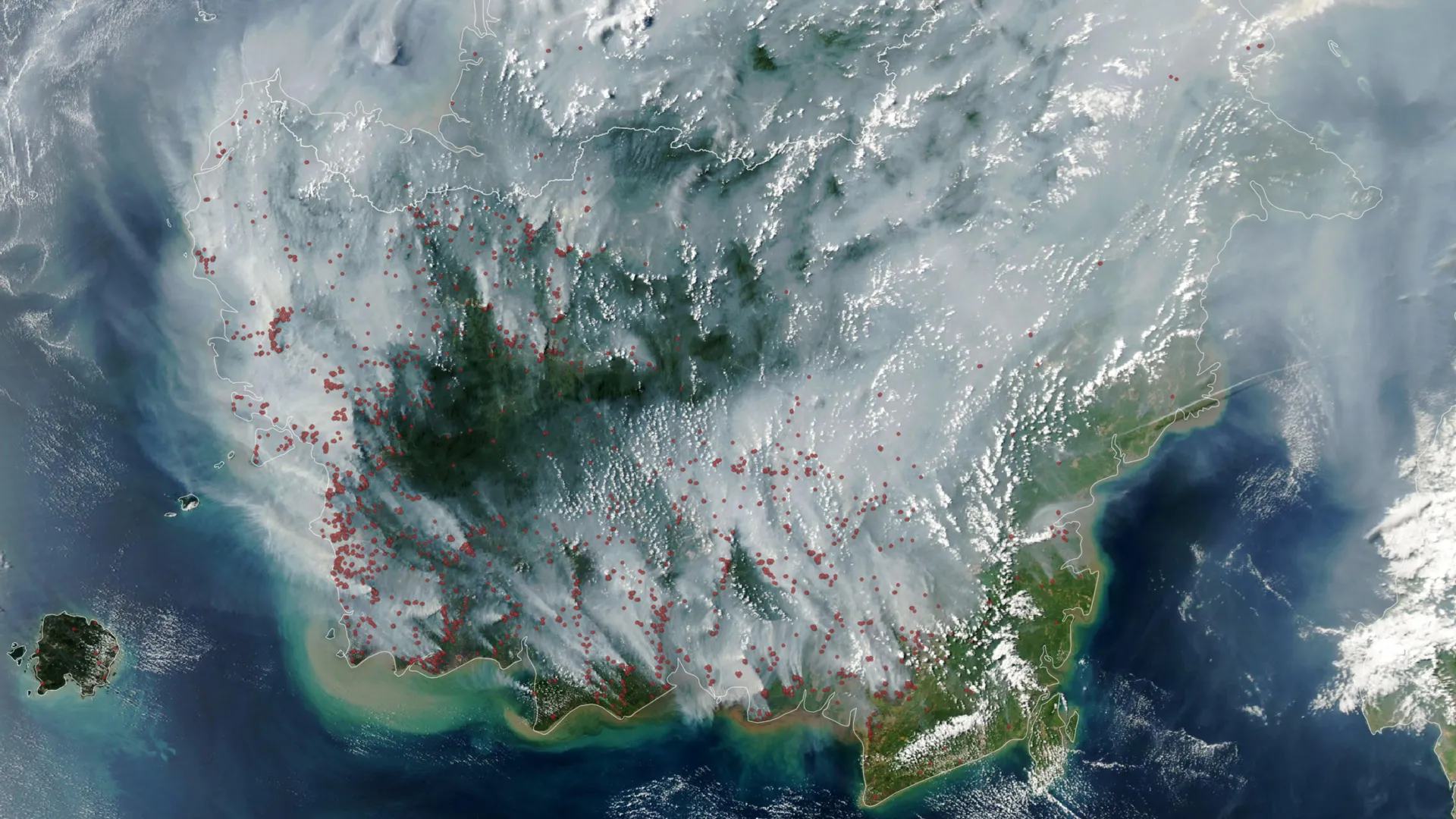
Indonesia’s critical 2026 fire season underscores a grave environmental and public health crisis, as extensive tropical peatland fires burn persistently beneath the surface, releasing staggering volumes of greenhouse gases and toxic particulate matter, exacerbated by a potent El Niño event. These deeply rooted blazes, exceptionally challenging to detect and extinguish, represent a significant threat to regional air quality, global climate stability, and the well-being of millions across Southeast Asia.
The Subterranean Threat: Unpacking Peatland Fires
Tropical peatland fires stand apart from conventional forest fires due to their unique combustion characteristics. Unlike conflagrations that rapidly consume above-ground biomass, these fires primarily smolder through the desiccated organic matter accumulated over millennia in wetland soils. Peat, a dense, carbon-rich material formed from partially decomposed plant matter, acts as a vast, subterranean fuel reservoir. When prolonged drought conditions deplete the water table that typically saturates these ecosystems, the exposed peat becomes highly susceptible to ignition. Once ignited, the low-temperature, smoldering combustion can propagate deep underground, often unnoticed on the surface, making these fires exceptionally tenacious and difficult to eradicate. This insidious nature ensures that the fires persist for extended periods, frequently for months, until heavy, sustained rainfall eventually extinguishes them.
A Toxic Plume: Environmental and Health Consequences
The environmental and health ramifications of peat fires are profoundly severe. Scientific estimates indicate that peat combustion generates a disproportionately high volume of hazardous emissions compared to other tropical forest fires. For instance, these fires are estimated to produce three times more fine particulate matter (PM2.5), five times more sulfur dioxide, three times more organic carbon, and twice as much methane and carbon monoxide.
Fine particulate matter, specifically PM2.5, poses a critical public health hazard, penetrating deep into the respiratory system and contributing to a wide array of ailments, including chronic respiratory diseases, cardiovascular issues, and premature mortality. The thick, acrid haze produced by these fires routinely blankets vast areas, often extending across national borders to Singapore, Malaysia, and beyond, disrupting daily life, air travel, and economic activity. Beyond immediate health impacts, the release of potent greenhouse gases like methane (CH4) and carbon monoxide (CO) significantly exacerbates global climate change. Methane, in particular, possesses a global warming potential far greater than carbon dioxide over shorter timescales, making peat fires a substantial, albeit often overlooked, contributor to atmospheric warming. The sheer volume of stored carbon released from these ancient deposits represents an irreversible loss, fundamentally altering the carbon balance of these critical ecosystems.
Indonesia’s Peatland Vulnerability
Indonesia holds the largest expanse of tropical peatlands globally, accounting for approximately 36 percent of the world’s total. These ecosystems, predominantly found across Sumatra, Kalimantan, and Papua, are naturally waterlogged, acting as vital carbon sinks and biodiversity hotspots. However, decades of extensive human intervention have rendered them acutely vulnerable. The natural hydrological balance of these wetlands has been severely disrupted by large-scale drainage projects, primarily undertaken to facilitate agricultural expansion, including vast rice farms, and more recently, the establishment of oil palm and acacia plantations. The construction of intricate canal networks, while serving short-term economic goals, has effectively desiccated vast tracts of peatland, lowering the water table and transforming naturally fire-resistant landscapes into highly combustible terrain. This fundamental alteration of the hydrological regime is the primary anthropogenic driver behind the persistent peat fire crisis.
The 2026 Conflagration: An Unfolding Crisis
The 2026 fire season in Indonesia commenced with an ominous trajectory, quickly escalating to levels reminiscent of historical crises. Satellite imagery from instruments such as the Moderate Resolution Imaging Spectroradiometer (MODIS) aboard NASA’s Aqua satellite, captured on September 1, 2026, revealed a significant proliferation of "fire detections" across the region. These thermal anomalies, identified by advanced algorithms, serve as critical indicators of active burning, even if a single fire can generate multiple data points. The rapid increase in these detections signaled an early and intense start to the dry season’s destructive potential, setting the stage for what many experts anticipated would be a severe challenge. The initial data indicated a concerning acceleration of fire activity, drawing parallels to the catastrophic 2015 season.
Climatic Drivers: El Niño and the Indian Ocean Dipole
The severity of Indonesia’s fire seasons is intrinsically linked to global climate patterns, most notably the El Niño-Southern Oscillation (ENSO) phenomenon. Historical data confirms that the most destructive fire years, such as 1997 and 2015, coincided with strong El Niño events. In August 2026, the National Oceanic and Atmospheric Administration (NOAA) confirmed the presence and strengthening of an El Niño, a climatic pattern known to significantly reduce rainfall across Indonesia.
Adding to this atmospheric burden, a positive phase of the Indian Ocean Dipole (IOD) was also underway. The IOD is an irregular oscillation of sea surface temperatures in the Indian Ocean, and its positive phase typically results in warmer waters in the western Indian Ocean and cooler waters in the eastern Indian Ocean, further suppressing rainfall over much of Indonesia. The concurrent occurrence of a strong El Niño and a positive IOD creates a synergistic effect, profoundly exacerbating drought conditions and rendering the peatlands exceptionally susceptible to ignition and prolonged burning. This "double whammy" of climatic forces effectively amplifies the aridity, creating ideal conditions for fire propagation. Robert Field, a Columbia University researcher and developer of the Global Fire Weather Database, observed the alarming trend: "Indonesia is only about three weeks into its fire season, but we’re seeing fire activity track sharply upward, similar to 2015. The strong El Niño is making the dry season drier over the fire-prone parts of the country and exacerbating burning—just as we anticipated it would."
Emissions and Global Climate Footprint
The comparison of the 2026 fire season to the devastating 2015 crisis offers a stark illustration of the immediate and long-term implications. In 2015, after more than three months of relentless burning, Indonesia’s fires emitted an estimated 1.75 billion tons of greenhouse gas equivalents (CO2e), a volume exceeding Japan’s total annual emissions. Alarmingly, by September 2, 2026, just one month into the peak fire season, the cumulative emissions had already reached approximately 10 percent of the total produced during the entire 2015 crisis. This rapid accumulation of greenhouse gases underscores the immense carbon debt being incurred and highlights the profound global climate implications. The release of such vast quantities of stored carbon further complicates international efforts to mitigate climate change and achieve global emission reduction targets. The 2026 trajectory indicates a potential for emissions to rival or even surpass those of the 2015 catastrophe, posing an existential threat to climate stability.
The Hidden Inferno: Challenges of Subsurface Combustion
The fundamental challenge in combating Indonesia’s peat fires lies in their subterranean nature. Under normal hydrological conditions, the peat deposits in regions like Kalimantan, Sumatra, and Papua remain saturated, preventing fire from penetrating beneath the surface. However, the severe and widespread drought experienced during the summer of 2026, mirroring the conditions of 2015, dramatically altered this dynamic. When peat dries sufficiently, it transforms into a highly combustible fuel that can ignite and smolder deep underground. "Surface fires are less of a concern, but when fires get underground, they just won’t stop," Field emphasized. "They’ll keep burning until the rains come in October or November." This persistence stems from the inaccessibility of the smoldering front, making conventional firefighting methods largely ineffective. Extinguishing these deep-seated fires requires immense volumes of water, often beyond logistical capabilities, and even then, re-ignition from residual heat is a constant risk. Consequently, the ultimate cessation of these underground infernos often hinges on the arrival of the monsoon rains, leaving communities exposed to hazardous smoke for months.
Monitoring the Invisible: Satellite Limitations and Innovations
Indonesia’s fire management strategy heavily relies on near-real-time observations from international satellite platforms, including NASA and NOAA instruments like MODIS and VIIRS. The Indonesian Ministry of Forestry’s SiPongi fire-monitoring platform actively utilizes this data, reporting 946 hotspots on August 31, 2026. However, satellite monitoring presents significant limitations, particularly concerning deeply smoldering peat fires. MODIS and VIIRS, while effective for surface fires, struggle to detect blazes obscured by dense smoke plumes, hidden beneath thick forest canopies, or burning entirely underground within peat deposits.
Mark Cochrane, an ecologist at the University of Maryland Center for Environmental Science with extensive field experience in Indonesian peat fires, highlighted a critical paradox: "The worst smoke events, paradoxically, can be the hardest to observe from space with MODIS and VIIRS." The very smoke generated by intense fires can block the satellite sensors’ view, leading to an underestimation of the true scale of the crisis. To address these limitations, researchers like Shi Jun Wee, a University of Maryland graduate student, are pioneering improved detection methods. Wee’s team, in collaboration with NASA and MapBiomas, is developing techniques that leverage shortwave infrared observations from Landsat and Sentinel-2 satellites, which offer enhanced capabilities for identifying understory fires and fires obscured by smoke. These innovations are crucial for providing a more accurate assessment of the fire landscape and informing targeted response efforts. Wee plans to continuously monitor conditions using advanced data browsers and fire information systems, integrating multiple satellite data streams to gain a comprehensive picture.
Decades of Degradation: The Anthropogenic Roots
The contemporary vulnerability of Indonesia’s peatlands to catastrophic fires is not a recent phenomenon but rather a consequence of decades of unsustainable land-use practices. Cochrane points to extensive irrigation canal construction and peat swamp drainage during the 1990s, notably associated with large-scale agricultural initiatives such as the "Mega Rice Project." These ambitious projects, aimed at bolstering food security and economic development, inadvertently lowered water tables across vast wetland areas, fundamentally altering the natural hydrology and rendering the landscape highly combustible. Subsequent expansion of oil palm and pulpwood plantations further perpetuated this cycle of drainage and degradation, often involving "slash and burn" techniques for land clearing, which frequently lead to uncontrolled peat fires. These systemic land-use changes have created a legacy of environmental fragility, transforming pristine carbon sinks into ticking carbon bombs.
Post-Crisis Interventions and Their Test
The devastating 2015 fire season served as a critical wake-up call, prompting concerted efforts by the Indonesian government and international organizations to implement preventative measures. These interventions have included ambitious peatland restoration projects, such as blocking drainage canals to rewet desiccated peat, strengthening national firefighting capabilities, and enhancing community-level engagement to prevent accidental human-caused ignitions. Significant policy shifts aimed at regulating land concessions and promoting sustainable land management practices have also been introduced.
The 2026 fire season, with its severe climatic drivers, represents a crucial "stress test" for the efficacy and resilience of these post-2015 measures. As Shi Jun Wee observed, "This year will be a real stress test of the measures that were put in place after 2015." The ability of these initiatives to mitigate the scale and impact of the current fires will provide vital insights into their long-term viability and the need for further refinement or expansion. The unfolding crisis will determine whether these efforts have sufficiently addressed the underlying vulnerabilities or if more transformative changes are required.
Life Under the Haze: Societal Disruption
For millions living in Indonesia and neighboring countries, the impacts of the 2026 fires are tangible and immediate. Indonesian authorities have issued severe warnings regarding widespread exposure to hazardous smoke, leading to significant public health concerns. News reports confirm widespread societal disruption: schools have transitioned to remote learning, numerous national parks have been closed to the public, and air travel has experienced substantial delays and cancellations due to severely reduced visibility. The economic consequences extend to agriculture, fisheries, and tourism, creating a cascading effect on livelihoods and regional economies. The transboundary nature of the haze also strains diplomatic relations with neighboring nations, highlighting the regional security implications of these environmental disasters.
Beyond the Fire Season: The Imperative for Sustained Action
The cyclical nature of Indonesia’s peat fire crisis, often peaking during El Niño events and then receding from public consciousness, poses a significant barrier to long-term solutions. As Cochrane aptly cautioned, "People tend to focus on these fires during an El Niño and then forget about them. We need sustained focus, even during the years when they aren’t as bad, to solve this. These fires create a tremendous amount of emissions." Addressing this complex issue requires a multi-faceted and sustained commitment beyond immediate crisis response. This includes robust enforcement of land-use regulations, accelerating peatland rewetting and restoration efforts at scale, investing in sustainable agricultural practices that do not rely on peatland drainage, and fostering greater community resilience through education and alternative livelihoods.
The 2026 fire season serves as a potent reminder that the consequences of historical land degradation, amplified by a changing climate, demand continuous attention and integrated strategies. Without a fundamental shift towards sustainable land management and a long-term commitment to peatland protection, Indonesia will continue to face the devastating cycle of subterranean fires, with profound implications for its people, its environment, and the global climate. The imperative is clear: the solution lies not just in fighting fires, but in preventing the conditions that allow them to ignite and smolder indefinitely.




 Aura Kasih
 Safa Marwah