
 Ayu Aulia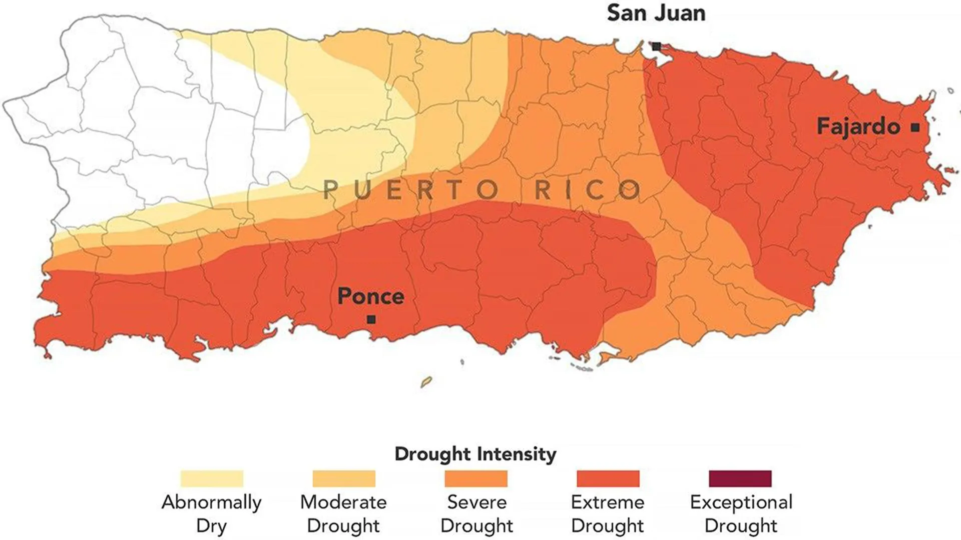
Puerto Rico is confronting a severe hydrological crisis, as an atypical failure of its traditional wet season in 2026 has propelled large swaths of the island into extreme drought conditions, necessitating emergency measures and federal disaster declarations to mitigate widespread water shortages and agricultural devastation.
Anomalous Weather Patterns Disrupt Hydrological Cycle
Historically, May marks the commencement of Puerto Rico’s vital wet season, a period crucial for replenishing reservoirs and groundwater supplies after the drier winter months. However, 2026 has diverged sharply from this established meteorological pattern. By late August, the anticipated rainfall had largely failed to materialize across significant portions of the U.S. territory, leading to a rapid and concerning expansion of drought. This acute lack of precipitation has not only strained the island’s water infrastructure but also triggered a series of emergency responses, including the implementation of water rationing in numerous communities and a gubernatorial declaration of a state of emergency in late July. Further underscoring the severity of the situation, the U.S. government issued a drought disaster declaration in late August, encompassing over two dozen municipalities and opening pathways for crucial federal assistance.
The abrupt shift in precipitation patterns raises critical questions about climate variability and long-term trends impacting the Caribbean. Puerto Rico, situated in a region highly susceptible to climatic fluctuations, relies heavily on consistent rainfall to support its dense population, agricultural sector, and vibrant ecosystems. The failure of a predictable seasonal onset can be indicative of broader atmospheric anomalies, potentially linked to shifts in ocean temperatures or large-scale atmospheric circulation patterns that divert moisture-laden air masses away from the island. Understanding these underlying meteorological drivers is paramount for developing more resilient water management strategies.
Scientific Monitoring Reveals Rapid Deterioration
The escalating crisis is meticulously tracked by the U.S. Drought Monitor, a collaborative scientific endeavor that synthesizes a wide array of data to produce weekly assessments of drought severity and geographic extent. This initiative, a partnership between the National Drought Mitigation Center at the University of Nebraska-Lincoln, the U.S. Department of Agriculture (USDA), the National Oceanic and Atmospheric Administration (NOAA), and NASA, provides critical insights into the evolving conditions. NASA’s involvement, which has historically provided Earth observations and scientific expertise, significantly expanded in 2026, with two of its scientists joining the core team responsible for generating these vital weekly drought maps.
David Mocko, a senior research scientist from NASA’s Hydrological Sciences Laboratory at Goddard Space Flight Center, highlighted the pervasive evidence of the unusually hot and dry conditions across the diverse data streams utilized by the U.S. Drought Monitor. For the Puerto Rico assessments, particularly crucial information included high-resolution satellite estimates of soil moisture, complemented by ground-based weather measurements and real-time observations of streamflow and well conditions. This integrated approach allows for a comprehensive understanding of both surface and subsurface hydrological stress. Mocko himself was responsible for preparing the U.S. Drought Monitor update for August 18, 2026, marking a significant milestone as he and Jonathan Case from NASA’s Marshall Space Flight Center became the first NASA scientists to directly contribute to the production of these authoritative weekly maps. Their expertise in satellite remote sensing and hydrological modeling offers enhanced capabilities for discerning subtle changes in water availability across complex terrains.
Severity and Speed of Onset Unprecedented
The August 25, 2026, assessment from the U.S. Drought Monitor painted a grim picture, indicating that approximately three-quarters of Puerto Rico was grappling with at least moderate drought conditions. More alarmingly, extreme drought zones, depicted in dark orange on the monitoring maps, had expanded considerably during the preceding week. These severe areas, concentrated in the eastern and southwestern regions of the main island, now encompassed a staggering 44 percent of the territory.
The rapidity of this deterioration is particularly striking. A mere three months prior, at the beginning of the traditional wet season, no part of Puerto Rico was classified as being in drought, and less than 20 percent of the territory was even considered abnormally dry. This dramatic shift underscores the acute nature of the 2026 event. Paradoxically, the late winter and early spring periods had been characterized by wetter-than-normal conditions across the U.S. Caribbean, according to a report by the National Integrated Drought Information System (NIDIS). This sudden and sharp pivot towards aridity highlights a profound disruption in the regional climate system, challenging established hydrological norms and preparedness frameworks.
Significant Precipitation Deficits and Compounding Heat
The core of the crisis lies in a substantial deficit of rainfall. From mid-May through mid-July, the majority of Puerto Rico received less than 60 percent of its average precipitation for that period, as reported by NIDIS. Southern and southwestern areas, which were later identified as extreme drought zones, fared even worse, recording less than 20 percent of their normal rainfall. This translated into a significant precipitation shortfall of 3 to 6 inches (76 to 152 millimeters) across affected regions, a deficit that severely impedes water replenishment.
Compounding the problem, persistently high temperatures exacerbated the drying conditions. San Juan, the capital, experienced one of its warmest Julys on record, intensifying evaporation rates from reservoirs, soil, and vegetation. This dual impact of reduced rainfall and increased evaporative demand created a potent feedback loop, accelerating the desiccation of landscapes and pushing hydrological systems to their limits. River levels, a critical indicator of surface water availability, plummeted sharply, with streamflow reaching unprecedented lows in several waterways, including the Rio Fajardo in northeastern Puerto Rico. Such extreme reductions in river flow directly impact water treatment plants that draw from these sources, as well as the ecological health of the riverine systems.
Profound Socio-Economic and Agricultural Disruptions
The scarcity of water has imposed immense burdens on the population, agricultural sector, and economy of Puerto Rico. Water rationing, a measure of last resort, has been enforced in several municipalities since early August, profoundly disrupting daily life. Residents face scheduled interruptions to their water supply, necessitating careful planning for basic hygiene, cooking, and household chores. Beyond residential impacts, businesses reliant on continuous water supply, such as laundromats, restaurants, and car washes, experience significant operational challenges and financial losses. News reports also indicate that underlying infrastructure issues, such as aging pipes and leaks within the water distribution network, have exacerbated the shortages, causing substantial water loss before it reaches end-users.
The agricultural sector, a vital component of Puerto Rico’s economy and food security, has been particularly hard-hit. Dry soils have severely impeded the growth of staple crops, including fruit trees, cacao, banana plants, and coffee, leading to considerable crop losses. This not only threatens the livelihoods of farmers but also has implications for local food prices and the island’s broader economic stability. Ranchers are facing critical challenges as well, with dwindling hay supplies jeopardizing their livestock. The long-term effects of such a severe drought on soil health and future agricultural productivity are a serious concern, potentially requiring extensive recovery efforts.
The Role of Drought Monitoring in Crisis Management
The U.S. Drought Monitor maps, which have been consistently published since 1999, serve as an indispensable tool for federal, state, local, and tribal officials in guiding drought response decisions. Their standardized, scientifically robust assessments provide a clear, actionable picture of conditions across the nation.
For instance, the USDA relies heavily on these maps as part of its "fast track" process for issuing disaster designations. These designations are not merely symbolic; they unlock a range of emergency assistance and resources for affected communities. This can include low-interest emergency loans for farmers and ranchers, grants for water infrastructure repairs, and technical assistance programs aimed at promoting drought resilience and recovery. The integration of NASA’s advanced Earth observation capabilities and scientific expertise into the U.S. Drought Monitor process further enhances the accuracy and predictive power of these maps, allowing for more timely and targeted interventions. By providing a common operating picture for all levels of government and stakeholders, the Drought Monitor facilitates a coordinated and effective response to complex hydrological crises.
Future Resilience and Adaptation Strategies
The 2026 drought in Puerto Rico serves as a stark reminder of the island’s vulnerability to climatic extremes and underscores the urgent need for robust adaptation strategies. Climate models project an increased frequency and intensity of extreme weather events, including both prolonged droughts and more intense rainfall events, for the Caribbean region in the coming decades. This anticipated variability necessitates a multi-faceted approach to water resource management.
Long-term resilience planning must encompass significant investments in water infrastructure modernization, including upgrading aging pipelines to reduce leakage, expanding reservoir capacity where feasible, and exploring alternative water sources such as desalination and advanced wastewater recycling. Implementing smart water management technologies, such as real-time leak detection systems and smart metering, can optimize distribution and encourage conservation.
In the agricultural sector, promoting drought-resistant crop varieties, improving irrigation efficiency through precision agriculture techniques, and diversifying agricultural practices are crucial. Educational campaigns aimed at fostering water conservation ethics among the general populace are also vital. Furthermore, strengthening early warning systems and developing community-level drought preparedness plans can help mitigate the immediate impacts of future dry spells. The collaborative efforts between scientific agencies like NASA and governmental bodies like the USDA highlight the importance of integrating cutting-edge science with policy and emergency response, paving the way for a more resilient Puerto Rico in the face of an uncertain climate future.




 Aura Kasih
 Safa Marwah