
The United Kingdom is grappling with a pervasive pattern of severe weather, as a series of powerful cyclonic systems has unleashed relentless rainfall and forceful winds, leading to extensive flooding, significant travel disruption, and widespread infrastructure strain across all four nations. This protracted period of atmospheric instability, exacerbated by already saturated ground conditions, has necessitated over one hundred active flood warnings, signaling an ongoing and critical risk to communities and transportation networks.
The latest in this succession of meteorological events, designated Storm Chandra, marked the third named storm to impact the British Isles within the nascent weeks of the year. Its arrival on Tuesday delivered a potent combination of heavy precipitation and gale-force winds, compounding the challenges posed by its predecessors. The confluence of these factors has triggered a cascade of emergency responses and advisories, with significant implications for public safety, mobility, and economic activity extending into the latter half of the week.
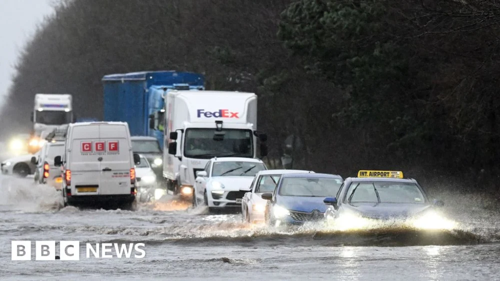
Throughout Wednesday morning, the geographical spread of flood advisories underscored the national scope of the crisis. Across England, environmental agencies had issued a staggering 100 flood warnings, indicating that flooding was either imminent or already occurring, alongside an additional 260 flood alerts, signifying the potential for inundation. Similarly, in Wales, three explicit flood warnings were active, complemented by 16 flood alerts. Scotland also faced considerable hydrological pressure, with eight flood warnings and an equal number of flood alerts in effect, reflecting the elevated risk of riverine and surface water flooding across diverse terrains.
The cumulative impact of these storm systems has been profound, particularly given the short interval between them. Storm Chandra’s direct predecessor, Storm Ingrid, had traversed the country just days prior, leaving behind a trail of damage and further saturating catchments already struggling to cope with antecedent rainfall. This hydrological overload meant that Chandra’s downpours rapidly translated into increased runoff and rising river levels, intensifying the flood risk in numerous regions. The Met Office, in its analysis, had previously characterized Storm Goretti, the initial named storm of the year, as one of the most impactful events to strike Cornwall and the Isles of Scilly in over three decades, setting a precedent for the severity of the current winter storm season.
Meteorological conditions during Chandra’s passage were particularly severe in certain locales. Tuesday witnessed two instances where severe flood warnings were escalated in England, denoting a direct danger to life. Although these critical warnings, issued for areas including Upper Frome in Dorchester and Ottery St Mary in Devon, have since been de-escalated, their temporary activation highlighted the extreme nature of the conditions. In Ottery St Mary, the River Otter reached its highest recorded level, a testament to the unprecedented volume of water flowing through the catchment. Eyewitness accounts from residents, such as Jackie Blackford, whose property overlooks the river, painted a vivid picture of the ferocity, describing the Otter as a "raging torrent" and expressing an unparalleled experience of its intensity.
The widespread nature of the disruption extended beyond direct flooding. Transportation networks bore a substantial brunt, with National Rail cautioning passengers that adverse weather conditions could impede rail services across England, Scotland, and Wales until Friday. This extended advisory underscores the complexity of recovery operations, which often involve inspecting track integrity, clearing debris, and managing signaling issues exacerbated by wind and water damage. In addition to rail, numerous domestic flight schedules and ferry crossings were subject to cancellations, disrupting both internal and international travel links and isolating some island communities.
Power infrastructure also suffered significant impacts. In Northern Ireland, at the peak of the storm, over 10,000 properties experienced power outages, indicative of the strain on electrical networks from high winds and falling debris. Gusts reached extreme speeds, with Orlock Head on the Ards Peninsula recording a peak of 80 mph, sufficient to cause extensive damage to overhead lines and utility poles. Beyond the UK mainland, the Republic of Ireland also experienced substantial disruption, with the Electricity Supply Board (ESB) reporting approximately 20,000 homes, farms, and businesses without power on Tuesday, demonstrating the broader regional reach of Storm Chandra’s influence.
The educational sector was not immune to the storm’s repercussions. On Tuesday, numerous schools across parts of England and Northern Ireland were compelled to close, either due to direct flooding, hazardous travel conditions, or power supply interruptions. In Northern Ireland alone, over 300 educational establishments ceased operations, impacting thousands of students and families. These closures highlight the immediate societal ramifications of severe weather, extending beyond direct property damage to affect daily routines and essential services.
Hydrological data from the storm’s passage revealed record-breaking rainfall figures in several locations. Katesbridge in Northern Ireland, Mountbatten in Plymouth, and Hurn in Dorset all registered new daily rainfall records for January, indicating the exceptional intensity and volume of precipitation delivered by Storm Chandra. Such records provide critical insights into changing weather patterns and the increasing frequency of extreme rainfall events, which challenge existing drainage and flood defense infrastructures.
The ongoing "yellow warnings" for ice, in effect across much of the country during Wednesday morning’s rush hour, further complicate the situation. Following periods of heavy rain and plummeting temperatures, residual surface water can rapidly freeze, creating treacherous driving and walking conditions. This secondary hazard amplifies the risks to commuters and emergency responders, requiring additional vigilance and resources for road treatment and public safety advisories.
The declaration of a major incident in Somerset, where an estimated 50 properties were inundated by floodwaters, exemplifies the localized yet severe impact of these events. This designation triggers enhanced coordination among emergency services and local authorities, allowing for a more robust and unified response to mitigate immediate dangers and support affected communities. The region remains under a yellow rain warning for Thursday, signaling that the threat of further disruption is not yet abated, and recovery efforts must contend with the potential for renewed precipitation on already saturated ground.
From a meteorological perspective, the succession of named storms in January suggests a highly active North Atlantic storm track, likely influenced by a persistent strong jet stream. The jet stream, a ribbon of fast-moving air high in the atmosphere, guides low-pressure systems across the Atlantic towards Europe. When it adopts a southerly track, as has been observed, it can direct powerful storm systems directly towards the British Isles, often bringing periods of intense rainfall and strong winds. The confluence of these dynamic atmospheric conditions with already saturated ground conditions creates a particularly challenging scenario for flood management and infrastructure resilience.
The economic implications of such widespread disruption are considerable. Beyond the immediate costs of emergency response and property damage, there are broader impacts on local economies, including business interruption, agricultural losses, and increased insurance claims. The cumulative effect of multiple storm events within a short timeframe also places significant strain on public finances, requiring substantial investment in both immediate recovery and long-term climate adaptation strategies. This includes enhancing flood defenses, improving drainage systems, and building greater resilience into critical infrastructure networks.
Looking ahead, the recovery from Storm Chandra and its predecessors will be a prolonged process. While the immediate danger posed by the most severe flood warnings has receded, the legacy of saturated ground, elevated river levels, and damaged infrastructure will persist. Public awareness, adherence to official warnings, and collaborative efforts between government agencies, local communities, and emergency services will be paramount in navigating the ongoing challenges and preparing for future meteorological events. The current sequence of storms serves as a stark reminder of the escalating risks associated with extreme weather and the imperative for robust national strategies to enhance climate resilience.