

The United Kingdom is bracing for a significant shift in its meteorological landscape, as the national forecasting agency issues extensive yellow warnings for powerful winds set to sweep across northern regions, concurrently with a notable drop in temperatures and the imminent arrival of snow over higher elevations. This pronounced change in weather patterns, driven by an exceptionally vigorous Atlantic jet stream, is poised to introduce considerable disruption to travel networks and daily life, prompting urgent advisories for residents and infrastructure operators across the affected territories.
Intensifying Wind Conditions Across Northern UK
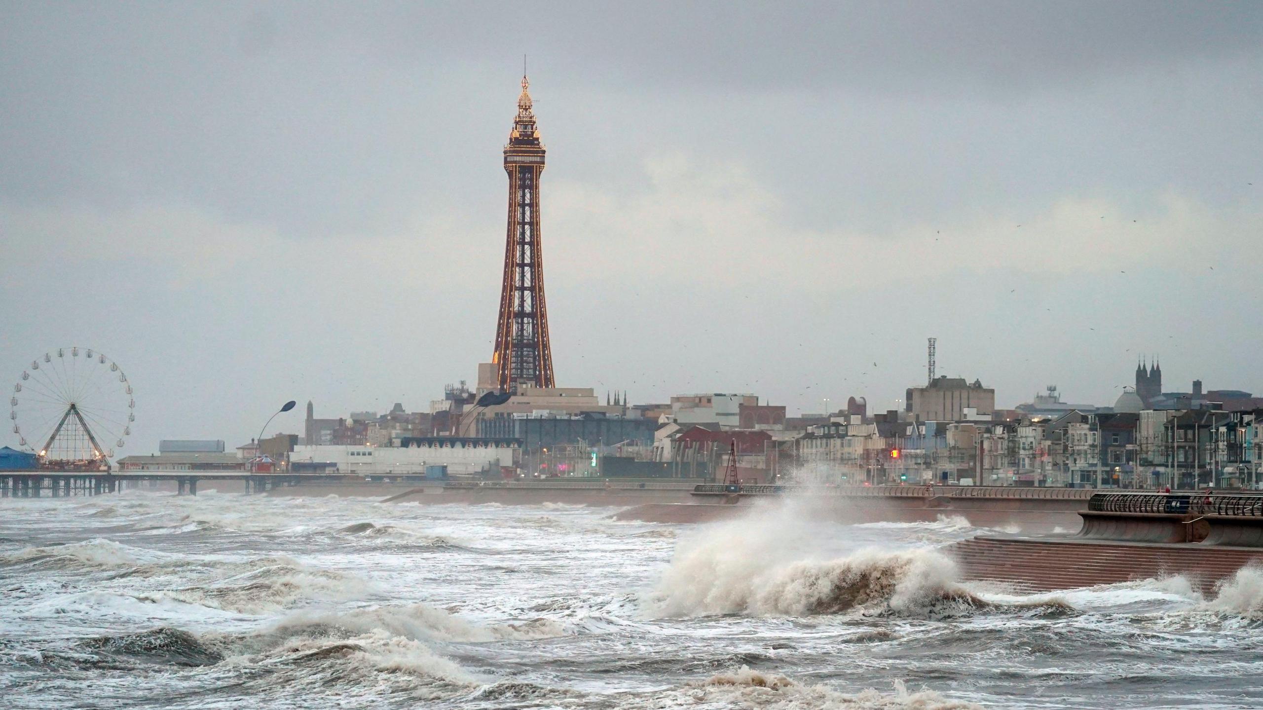
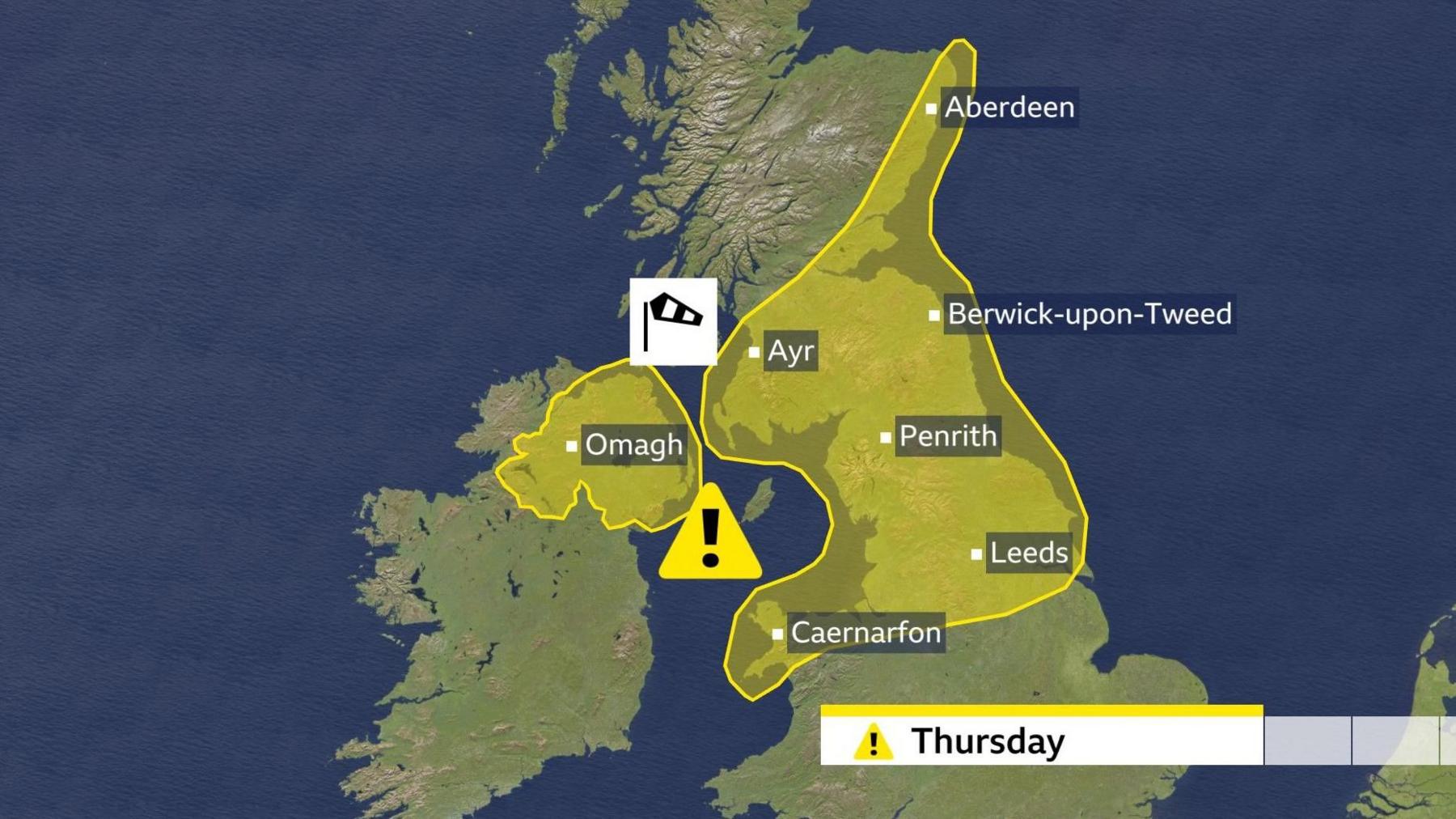
Beginning on Thursday, a substantial portion of the northern UK, encompassing Scotland, Northern Ireland, northern England, North Wales, and the northern Midlands, will experience a pronounced increase in wind speeds. These conditions are anticipated to manifest in the form of widespread gales, with gusts projected to reach between 50 and 60 miles per hour (mph) across many areas. Forecasters caution that isolated gusts could potentially exceed 70 mph in particularly exposed coastal and elevated locations, presenting a considerable hazard.
The onset of these robust winds will be phased, with Northern Ireland and Scotland experiencing the peak intensity during the morning hours. In these regions, the strongest gusts are expected to coincide with the passage of a cold front, a meteorological boundary marking the transition from warmer to significantly colder air. This frontal system will also bring heavy rainfall before the winds abruptly diminish in strength following its progression. The Hebrides, in particular, are highlighted as an area where a brief period of exceptionally strong gusts could materialise, raising concerns for maritime operations. Scottish ferry services have already been identified as vulnerable to delays and cancellations, necessitating passengers to consult real-time travel updates prior to commencing journeys.

Further south, including northern England, the North Midlands, and North Wales, the wind speeds will progressively intensify throughout the morning, reaching their zenith during the afternoon. The geographical reach of these powerful winds is noteworthy; they are not expected to be confined solely to coastal fringes or the summits of hills but will extend well inland, impacting regions to the east of prominent geographical features such as the Pennines and the Cheviot Hills. This broad distribution amplifies the potential for widespread disruption, particularly for transportation infrastructure.
Implications for Transport and Public Safety
The anticipated wind conditions carry significant implications for various modes of transport. High-sided vehicles are particularly susceptible to the strong crosswinds, making travel on exposed routes perilous. Major arterial roads such as the northern sections of the M6 motorway, the A68, and the A1 are predicted to present some of the most challenging driving conditions. Road users are strongly advised to exercise extreme caution, consider alternative routes, or postpone non-essential travel during the peak wind periods. Beyond direct travel risks, the force of the wind could lead to minor structural damage, dislodge unsecured objects, and potentially disrupt power supplies in localized areas. Residents in affected regions are encouraged to secure any outdoor items that could become airborne and to remain vigilant regarding potential hazards.
The transition from the warmer, windier conditions to the colder air mass will be swift and pronounced. As the cold front advances southwards, a significant drop in ambient temperatures is expected to follow, fundamentally altering the atmospheric profile across the UK.
Mountainous Regions Prepare for Significant Snowfall
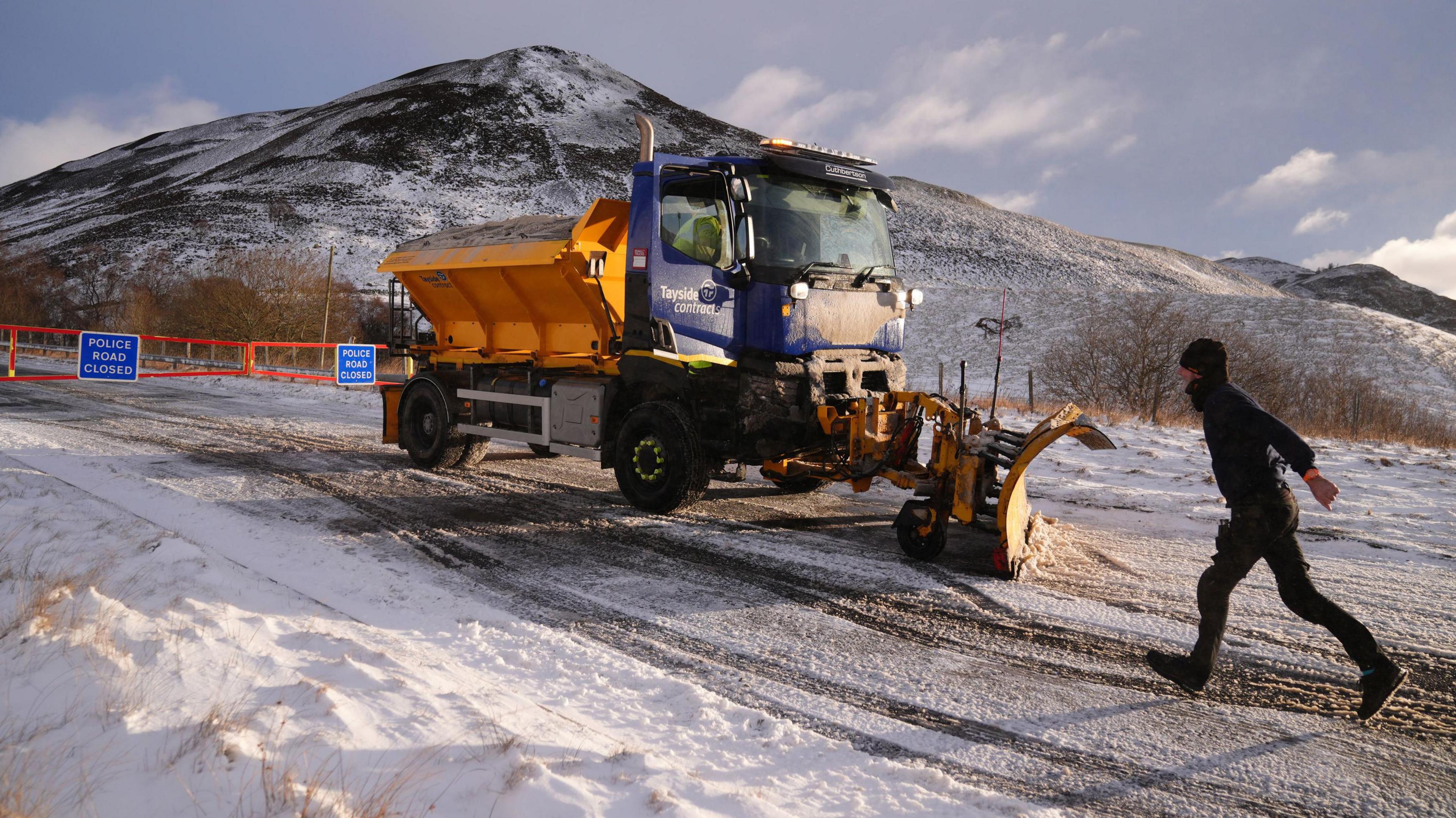
As the week draws to a close, the advent of this colder air mass will introduce a substantial risk of wintry precipitation across the northern UK. From Thursday night and continuing into Friday, frequent showers are forecast to turn increasingly wintry, particularly over elevated terrain. Snowfall is highly probable across high ground in Scotland, Northern Ireland, northern England, and North Wales, generally at elevations above 200 metres.
In the most elevated parts of Scotland, specifically the mountainous ranges, forecasters project significant accumulations. There is a strong possibility of 10 to 20 centimetres of snow settling, which could lead to considerable disruption for high-altitude communities and transport links. Roads traversing mountain passes, such as the A93 in Scotland, are particularly vulnerable to blockages and hazardous driving conditions, requiring snow plough operations and potentially temporary closures. Outdoor enthusiasts and those planning activities in mountainous regions are strongly cautioned about the rapidly deteriorating conditions, including reduced visibility and the risk of hypothermia due to the combination of cold, wind, and snow.
Friday’s Shifting Weather Landscape
Friday is expected to present a day characterised by a mosaic of sunshine and showers. The showers will be most prevalent and frequent in the northern and western parts of the UK. These convective showers are anticipated to be vigorous, bringing not only rain but also hail and, in some instances, isolated cracks of thunder. However, due to the persistent gusty winds, these showers are unlikely to linger for extended periods, being rapidly propelled across the sky. Despite the intermittent sunshine, the overall feel of the day will be distinctly colder, underscoring the shift to a more wintry atmospheric regime.
The Influence of the Potent Atlantic Jet Stream
The underlying meteorological driver for this episode of robust winds and colder conditions is a particularly powerful Atlantic jet stream. This high-altitude, fast-flowing air current, which can reach speeds of up to 220 mph, plays a critical role in shaping weather patterns across the North Atlantic and Western Europe. Its increased intensity and southerly trajectory have been instrumental in generating and steering a series of intense low-pressure systems across the ocean.
While the centres of these powerful low-pressure systems have largely remained a considerable distance to the northwest of the UK mainland, their sheer intensity and proximity have been sufficient to extend their influence across the British Isles, resulting in the observed strong winds. This dynamic illustrates how remote atmospheric phenomena can exert profound effects on local weather. Recent observations corroborate this activity, with widespread gales reported across Scotland on Wednesday. Notable gusts included 74 mph recorded in South Uist Range in the Hebrides, and 68 mph in Orkney, which had already led to the cancellation of certain ferry services, providing a prelude to the more widespread warnings now in effect.
Outlook for the Weekend and Beyond: Sustained Unsettled Conditions
The unsettled weather pattern is expected to persist into the upcoming weekend and the early part of the following week. Further periods of strong winds are forecast, alongside additional wintry showers, particularly on Sunday and Monday. This suggests a prolonged period of vigilance for residents and authorities. The continued influence of the energetic jet stream indicates that the UK will remain under the sway of a dynamic atmospheric environment, with the potential for further weather fronts and associated warnings.
Preparing for the Disruptive Weather
In light of these forecasts, proactive measures are highly recommended. The Met Office and other official bodies consistently advise the public to stay informed through regular updates from reputable weather sources. Specific guidance includes:
- Travel Planning: Prioritising essential journeys, allowing extra time, and checking for real-time traffic and public transport updates before departure.
- Property Security: Ensuring loose items in gardens or on balconies are secured or brought indoors to prevent wind damage.
- Outdoor Activities: Exercising extreme caution or avoiding outdoor activities in exposed areas, particularly in mountainous regions, where conditions can deteriorate rapidly.
- Emergency Preparedness: Having contingency plans for potential power outages, especially in more remote areas, and ensuring adequate supplies of food, water, and warmth.
- Driving Safety: Being particularly aware of strong crosswinds if driving high-sided vehicles, caravans, or motorcycles, and adjusting speed accordingly.
This period represents a significant shift from milder conditions, requiring widespread public awareness and preparedness to mitigate potential impacts on infrastructure, transport, and personal safety. The confluence of powerful winds, heavy rainfall, and the introduction of mountain snow underscores the dynamic nature of the UK’s weather systems under the influence of the powerful Atlantic jet stream.