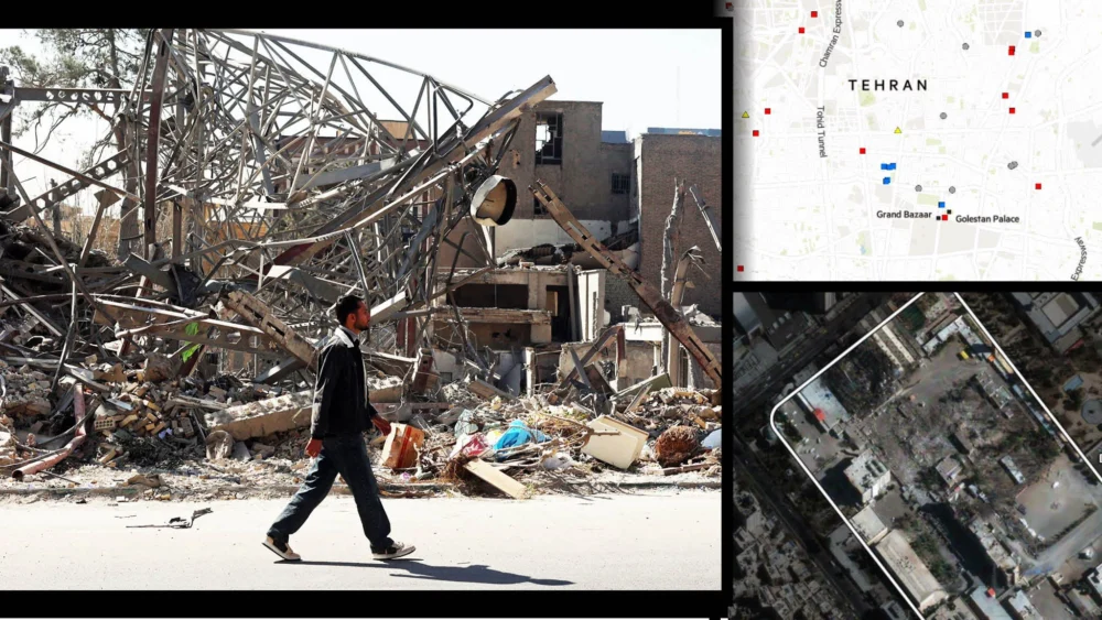
A meticulous examination of satellite imagery and geographical data offers an unprecedented glimpse into the potential impact and strategic considerations of a hypothetical aerial assault on Tehran, revealing a complex interplay of vital infrastructure, population density, and critical governmental functions. This analysis moves beyond a mere depiction of targets, instead delving into the intricate network of urban geography that would dictate the consequences of such an event.
The capital city of Iran, Tehran, is not merely a sprawling metropolis; it is the pulsating heart of the nation’s political, economic, and administrative power. Understanding its geography is paramount to grasping the potential ramifications of any hostile action. From a strategic perspective, Tehran presents a multifaceted target, encompassing not only overt military installations but also a dense concentration of civilian infrastructure and key decision-making centers. This analysis, informed by state-of-the-art satellite observation and advanced mapping technologies, aims to provide a comprehensive understanding of these vulnerabilities.
Mapping the Labyrinth: Tehran’s Urban Fabric and Strategic Significance
Tehran’s urban layout is a testament to decades of growth and development, characterized by a dense core surrounded by ever-expanding residential and industrial zones. The city’s geography is further influenced by its location at the foothills of the Alborz Mountains to the north, a factor that can affect air traffic patterns and potentially create localized weather phenomena. The north of the city, generally considered more affluent and home to many government ministries and embassies, contrasts with the more densely populated and historically working-class southern districts.
The strategic importance of Tehran cannot be overstated. It is the seat of the Iranian government, housing the presidential palace, the parliament (Majlis), and numerous ministries that orchestrate the nation’s domestic and foreign policies. Key military headquarters, intelligence agencies, and the command and control structures of the armed forces are also concentrated within or in close proximity to the capital. This concentration of power makes it a prime target for any actor seeking to disrupt Iran’s operational capacity or decapitate its leadership.
Critical Infrastructure: Arteries of a Nation Under Scrutiny
The city’s critical infrastructure forms a complex and interconnected web, essential for its functioning and thus a significant point of strategic consideration.
-
Transportation Networks: Tehran boasts an extensive network of highways, arterial roads, and a burgeoning subway system. Major highways like the Hemmat Expressway and its extensions form vital arteries. The presence of the Mehrabad International Airport, historically the primary gateway to the city, and the Imam Khomeini International Airport, located further afield but still crucial for national connectivity, represent significant logistical nodes. Disruption to these networks would have immediate and cascading effects on the movement of goods, personnel, and emergency services. Satellite imagery can reveal the precise routing of these highways, the location of major interchanges, and the scale of airport facilities, allowing for an assessment of their strategic value and vulnerability.
-
Energy and Utilities: The city’s power grid, water supply systems, and telecommunications infrastructure are indispensable for its population and economy. Key power generation facilities, substations, and pumping stations, often located strategically within or on the outskirts of urban areas, become potential targets. Mapping these utilities via satellite reveals their spatial distribution and interdependencies, highlighting potential points of systemic failure. For instance, the Tehran Thermal Power Plant, a significant contributor to the city’s energy needs, and various water treatment and distribution centers would be of paramount strategic interest.
-
Communication Hubs: In the modern era, control over information flow is a critical component of national power. Tehran is home to major telecommunications exchanges, broadcasting centers, and internet backbone nodes. Disrupting these facilities could cripple communication channels, affecting not only civilian life but also military command and control and governmental operations. High-resolution satellite imagery can identify the physical footprint of these facilities, their security perimeters, and their proximity to other critical assets.
Population Centers and Humanitarian Considerations
Tehran is one of the most populous cities in Western Asia, with an estimated population exceeding 8.6 million in the city proper and over 15 million in the wider metropolitan area. This immense population density presents a profound humanitarian challenge in the event of any hostile action.
-
Residential Zones: The sheer scale of residential areas, from high-rise apartment buildings to more spread-out neighborhoods, means that any widespread bombing campaign would inevitably result in significant civilian casualties and displacement. Satellite imagery can delineate the density and type of housing in different areas, providing a stark visualization of the human cost. The contrast between the densely packed apartment blocks in older districts and the more dispersed, affluent villas in the northern hills offers a glimpse into the varying impacts across different socio-economic strata.
-
Public Facilities: Hospitals, schools, and other public gathering places are integral to the urban fabric. While generally not considered primary military targets, their proximity to other strategic locations or their potential use as shelter could inadvertently draw them into conflict. Mapping these facilities provides a clearer picture of the potential impact on civilian services and the humanitarian response required.
Governmental and Military Nexus: The Epicenter of Power
The concentration of Iran’s governmental and military apparatus in Tehran makes it the undeniable nexus of national power.
-
Governmental Ministries and Offices: Numerous ministries, including those for foreign affairs, intelligence, defense, and interior, are located within the city. These institutions are responsible for the day-to-day administration and strategic direction of the country. Their disruption would paralyze governmental functions and undermine the state’s capacity to respond. Satellite imagery can identify the architectural characteristics and spatial organization of these complexes, often revealing their fortified nature and internal security measures.
-
Military Installations and Command Centers: While overt military bases might be located outside the immediate city limits, key command and control centers, intelligence headquarters, and logistical support facilities are often integrated within or adjacent to the urban environment. The presence of the Islamic Revolutionary Guard Corps (IRGC) headquarters and various military planning institutions within Tehran underscores its role as a strategic military hub. Identifying these locations through detailed satellite analysis is crucial for understanding the potential to degrade Iran’s military capabilities.
-
Nuclear and Sensitive Sites: While Iran’s primary nuclear facilities are located elsewhere, the capital could house research centers, laboratories, or administrative bodies related to its nuclear program, making them potential targets of interest. The precise location and nature of such facilities, often shrouded in secrecy, can sometimes be inferred through analysis of unusual infrastructure or activity patterns visible in satellite data.
The Strategic Calculus: Beyond Physical Destruction
The analysis of Tehran through maps and satellite imagery extends beyond merely identifying physical targets. It delves into the strategic calculus that would underpin any consideration of an aerial assault.
-
Deterrence and De-escalation: The sheer scale of Tehran’s population and the potential for widespread collateral damage would weigh heavily on any decision-making process. The humanitarian consequences could be catastrophic, potentially leading to regional instability and international condemnation. This realization can serve as a powerful deterrent.
-
Psychological Impact: Targeting the capital city, the symbol of national identity and sovereignty, would have a profound psychological impact on the population and the government. The aim might be to break morale, incite dissent, or force a change in policy. Satellite imagery can help visualize the density of civilian areas surrounding potential targets, underscoring the psychological weight of such actions.
-
Decapitation Strikes: The concentration of leadership and command structures in Tehran makes it a prime candidate for decapitation strikes, aimed at neutralizing the country’s decision-making capacity. However, the dispersed nature of Iranian leadership and the robust security measures in place would make such an objective exceedingly difficult to achieve with certainty.
-
Information Warfare: The digital infrastructure within Tehran is a critical component of its operational capacity. Attacks aimed at disrupting communication networks, propaganda dissemination, and cyber command capabilities could be as significant as kinetic strikes in achieving strategic objectives. Satellite imagery can help identify the physical locations of these critical nodes within the broader urban landscape.
Future Outlook and Implications
The continuous advancement of satellite technology, including higher resolution imagery, synthetic aperture radar (SAR) capabilities for all-weather imaging, and advanced analytical tools, allows for an ever-more detailed and dynamic understanding of urban environments like Tehran. This capability is crucial for intelligence agencies, policymakers, and strategic planners.
The insights gleaned from this cartographic and satellite-based examination of Tehran highlight the complex and interconnected nature of modern urban centers and their strategic significance. Any hostile action against such a city carries immense risks and far-reaching consequences, necessitating a deep and nuanced understanding of its intricate spatial and functional geography. The ability to visualize and analyze these vulnerabilities from above provides a critical, albeit sobering, perspective on the realities of modern conflict and the profound implications for civilian populations. This analytical approach, grounded in empirical data and sophisticated interpretation, is essential for informed decision-making in an increasingly complex geopolitical landscape.