
The United Kingdom finds itself under the immediate and intensifying grip of a formidable Arctic air mass, heralding the commencement of a protracted period of severe wintry conditions characterized by extensive snowfall, pervasive ice, and profoundly low temperatures, necessitating a comprehensive activation of meteorological and public health alerts across vast swathes of the nation as the new calendar year begins. This significant meteorological event is poised to test national resilience, impact critical infrastructure, and pose considerable risks to public well-being, demanding heightened vigilance and preparedness from both authorities and the populace.
The atmospheric dynamics responsible for this dramatic shift involve the southward displacement of a substantial polar air mass, originating from the high Arctic regions. This frigid air stream is being channeled directly towards the British Isles by a powerful high-pressure system positioned to the west, effectively blocking milder Atlantic influences and directing cold northerly winds across the entire archipelago. The arrival of this air mass on the cusp of the new year, a period traditionally associated with colder weather, marks the initiation of what meteorological projections indicate will be an extended duration of sub-zero temperatures and associated winter hazards, extending well beyond the immediate weekend.
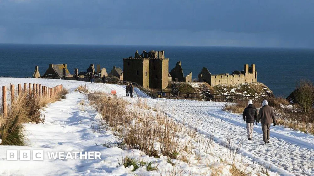
Early indicators of this atmospheric transition became apparent on New Year’s Eve, with revelers across southern England experiencing temperatures plummeting below the freezing point around the midnight hour. The first morning of the new year, January 1, 2026, dawned with a widespread and biting frost, underscoring the immediate and pervasive impact of the Arctic invasion. Specific overnight lows provided a stark illustration of the developing conditions: Bournemouth registered a chilling -6.2 degrees Celsius, while Cardiff experienced -2.5 degrees Celsius, with temperatures consistently remaining below zero across southern England and South Wales. Further north, a veil of cloud cover and intermittent precipitation initially mitigated the most severe overnight drops; however, the inexorable advance of the colder Arctic air subsequently ushered in substantial snowfall across Northern Scotland, signaling the full establishment of the wintry regime.
The immediate focus of the most intense snowfall activity is centered upon Northern Scotland, where the national meteorological service has issued a yellow warning for snow, valid until 23:59 GMT on Friday. This alert highlights the potential for significant accumulations, ranging from 2 to 10 centimeters at lower elevations, escalating dramatically to between 20 and 30 centimeters over higher ground. Crucially, these snowfall totals are expected to be compounded by strong winds, leading to considerable snow drifting and the formation of localized blizzards. The implications for regional connectivity are severe, with forecasters warning of substantial delays on major thoroughfares and a heightened risk of vehicles becoming immobilized or stranded. Furthermore, the prospect of certain rural communities becoming isolated due to impassable roads presents a significant challenge for emergency services and supply logistics, necessitating proactive contingency planning.
Beyond the immediate snowfall in the far north, the broader meteorological picture for New Year’s Day across the rest of the UK involves the progressive clearance of residual cloud cover and rain, moving southward. This will yield extensive periods of dry and sunny weather for many regions. However, any impression of milder conditions will be deceptive, as a robust northerly wind will ensure that the pervasive chill persists, making ambient temperatures, which are expected to range between 1 and 7 degrees Celsius, feel considerably colder. This combination of bright skies and biting winds underscores the dual nature of the cold spell: visually appealing but fundamentally harsh.
The profound impact of these low temperatures extends beyond mere discomfort, triggering significant public health concerns. The UK’s Health Security Agency (UKHSA) has taken the proactive step of issuing Amber cold health alerts, which encompass the entirety of England. These alerts are in effect until 12:00 GMT on January 6 and serve as a critical warning of the increased risks posed by sustained cold weather, particularly highlighting a potential rise in mortality rates among elderly individuals and other vulnerable populations. The vulnerabilities exacerbated by extreme cold are manifold, including increased susceptibility to hypothermia, respiratory illnesses, cardiovascular events, and accidental falls on icy surfaces.
The implications for the healthcare infrastructure are also considerable. The UKHSA alerts explicitly address the challenges faced by hospitals and care homes in maintaining internal temperatures at levels deemed safe and appropriate for assessing health risks, typically around 18 degrees Celsius. Furthermore, the agency acknowledges the broader societal challenge faced by many households in sustaining this recommended indoor temperature, a struggle often compounded by issues of energy poverty, inadequate insulation, and the escalating cost of heating. This scenario necessitates a concerted public health response, emphasizing preventative measures such as wearing multiple layers of clothing, consuming hot meals and beverages, and crucially, encouraging community vigilance through checking on elderly or vulnerable neighbors to ensure their warmth and well-being.
As the week progresses, the meteorological landscape is set to evolve, bringing further widespread wintry precipitation. Overnight into Friday, an expansive area of rain, sleet, and snow is projected to sweep across Northern Ireland, Wales, significant portions of North-West England, the Midlands, and southern England. In anticipation of this, the Met Office has issued a yellow warning for large sections of England and Wales, active from midnight on Friday until 12:00 GMT on January 2. A separate but concurrent yellow warning is in place for Northern Ireland, spanning from midnight until 10:00 GMT on Friday. While the snowfall in these regions is expected to be relatively short-lived, potentially lasting only a couple of hours, accumulations of 1 to 2 centimeters at low levels and up to 5 centimeters over the higher grounds of Wales and the southern Pennines are sufficient to cause localized travel disruption, particularly during peak commuting hours.
Meanwhile, the more persistent and intense snow showers over Northern Scotland are forecast to continue unabated throughout the weekend. The confluence of strong winds on Saturday will exacerbate conditions, generating widespread blizzards and significant snowdrifts. Projections indicate that the north-west Highlands and Grampians could witness extraordinary accumulations, potentially reaching as much as 60 centimeters of snow by the conclusion of the weekend. This extreme forecast has prompted the issuance of an additional Met Office yellow warning specifically for northern and western Scotland, covering the entire weekend period, underscoring the severity and extended nature of the threat to these regions.
Across the broader UK, temperatures throughout the weekend are anticipated to remain exceptionally low, struggling to reach between 3 and 5 degrees Celsius at best. Critically, some areas, particularly in Scotland and northern England, are expected to experience "ice-days," a meteorological phenomenon where temperatures fail to rise above freezing point for the entire 24-hour period. These persistently low daytime temperatures, combined with widespread and severe overnight frosts, are not transient phenomena. Current forecasts indicate that this pattern of intense cold is firmly entrenched and is expected to continue well into the following week, suggesting a prolonged period of challenging winter conditions that will demand sustained vigilance and adaptive responses from individuals and infrastructure alike.
The implications of such a prolonged cold snap are far-reaching, extending beyond immediate discomfort and travel disruption. Economically, sectors such as transport, retail, and agriculture face significant challenges. Gritting operations will be continuous, straining local authority budgets and resources. Energy demand is expected to surge, potentially placing strain on the national grid and influencing energy market dynamics. The health system, already under pressure, will likely experience an increase in cold-related admissions, diverting resources. From an environmental perspective, the persistent cold could impact biodiversity, while the eventual melt of heavy snow could pose localized flooding risks if not managed effectively. The sustained nature of this Arctic intrusion positions it as a significant test of national resilience, demanding a coordinated response and proactive measures to mitigate its multifaceted impacts. Continuous monitoring of evolving forecasts and advisories from official meteorological and health agencies remains paramount for navigating this challenging period.