
A significant meteorological event is poised to unfold across large swathes of England and parts of Wales, as the national weather service, the Met Office, activates a comprehensive yellow weather warning for heavy rain commencing at 12:00 GMT. This advisory encompasses critical regions including London, the entire South East, South West England, and specific areas within Wales, signalling a period of heightened atmospheric instability and potential disruption. The issuance of this warning follows an extended duration of persistent precipitation, which has already saturated ground conditions and elevated hydrological concerns across the country, prompting an urgent focus on flood preparedness and public safety.
The meteorological analysis indicates that the affected areas can anticipate widespread rainfall accumulations ranging from 10 to 15 millimetres (approximately 0.4 to 0.6 inches). However, specific localities, particularly those exposed to the anticipated strong south to south-easterly winds, could experience more intense downpours, with totals potentially reaching between 20 and 30 millimetres. Such rainfall volumes, especially when falling upon already saturated catchments, significantly increase the risk of surface water flooding and exacerbate existing riverine flood threats. The persistent and robust wind patterns are expected to contribute to the intensity and distribution of these showers, guiding moisture-laden air into vulnerable regions and potentially triggering localised flash flooding in urban areas.
The current weather system is not an isolated incident but rather the latest in a series of intense precipitation events that have characterised recent weeks and months. This sustained period of wet weather has left much of the UK’s landscape in a highly vulnerable state, with soil moisture deficits significantly reduced or non-existent. The hydrological consequence is that any new rainfall has an immediate and pronounced impact on river levels and surface water accumulation, as the ground’s capacity to absorb additional moisture is severely diminished. This antecedent condition is a critical factor in the Met Office’s assessment of flood risk, elevating a moderate rainfall event into one with potentially significant implications for communities.
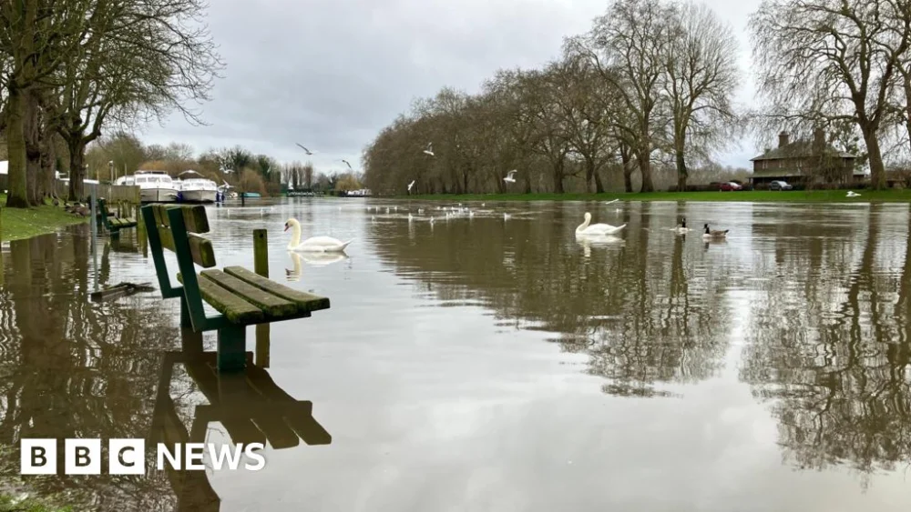
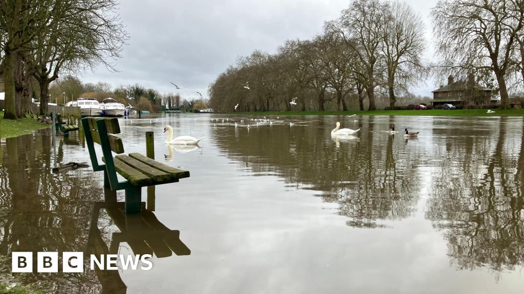
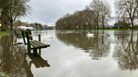
In response to the escalating threat, the Environment Agency, the principal body responsible for flood risk management in England, has already issued a substantial number of flood warnings and alerts. As of Sunday evening, the agency reported a total of 104 active flood warnings across England, indicating that flooding is either expected or imminent in these specific locations. Concurrently, 215 flood alerts were in effect, advising residents in broader areas to prepare for potential flooding. The geographical distribution of these advisories highlights particular vulnerabilities in the South West and the Midlands, regions that have borne the brunt of recent weather patterns. Beyond England, Scotland currently faces six flood warnings and two alerts, while Wales is contending with five flood alerts, underscoring the widespread nature of the prevailing meteorological challenges across the United Kingdom.
The Environment Agency’s operational teams are mobilised across the affected regions, implementing proactive measures to mitigate the impact of flooding and provide support to communities. Their activities typically include deploying temporary flood barriers, operating pumping stations, clearing blockages from watercourses, and providing direct assistance to residents in at-risk areas. These efforts are crucial in protecting critical infrastructure and residential properties, thereby reducing the overall socio-economic impact of severe weather events. The coordinated response between national agencies, local authorities, and emergency services is paramount during such periods to ensure effective resource deployment and timely public communication.
A stark illustration of the unusual weather patterns this year comes from the Met Office’s data, which indicated that specific regions, notably South West England and South Wales, experienced rainfall every single day in the opening period of the year. This unprecedented daily precipitation contributed to these areas receiving approximately 50% more rainfall than their usual averages for the period. Such statistics underscore the exceptional nature of the current hydrological situation, setting a challenging backdrop for any additional rainfall. The cumulative effect of these prolonged wet spells has progressively saturated ground conditions, rendering the landscape highly susceptible to even moderate rainfall events.
The first few weeks of the year have been particularly tumultuous, marked by a succession of three named storms that have battered the UK. These systems brought not only significant rainfall but also powerful winds, contributing to widespread disruption across various sectors. The impact extended to transportation networks, agricultural operations, and daily life for countless individuals. The naming convention for storms serves as an important communication tool, raising public awareness and facilitating a coordinated response from emergency services and infrastructure providers. The frequency and intensity of these recent named storms have prompted renewed discussions among meteorologists and climate scientists regarding the evolving patterns of extreme weather events in the region.
The Environment Agency has provided initial assessments of the immediate impact, estimating that approximately 300 properties have been reported as flooded on Sunday alone. Crucially, their proactive interventions and protective measures are believed to have safeguarded an additional 16,200 properties from inundation. This dual statistic highlights both the immediate challenge posed by severe weather and the effectiveness of ongoing flood defence strategies and rapid response capabilities. However, even with extensive protection, the human and economic toll of flooding remains substantial, affecting individual households, local businesses, and community infrastructure.
A critical safety message reiterated by Sarah Cook, the Environment Agency’s flood duty manager, is the imperative for the public to avoid driving through floodwater. She emphasised that the depth of floodwater is frequently underestimated and that even a relatively shallow depth of 30 centimetres (approximately 1 foot) of flowing water possesses sufficient force to lift and displace a typical car. Attempting to navigate flooded roads not only endangers the occupants of the vehicle but also places an unnecessary burden on emergency services, diverting critical resources from other urgent incidents. The advice underscores the inherent dangers associated with floodwater, which can conceal hidden hazards such as open manholes, damaged road surfaces, and strong currents.
Geographically, the current cluster of severe flood warnings is concentrated in specific areas, including Devon and Hampshire in the south, as well as the corridor between Gloucester and Worcester in the Midlands. These regions often feature extensive river networks and low-lying plains, making them particularly susceptible to riverine flooding following heavy rainfall in upstream catchments. Beyond these specific warning zones, over 200 flood alerts are distributed across the majority of England, with notable exceptions being the far north and East Anglia, which appear less directly impacted by the current system. This broad spatial distribution of alerts indicates a pervasive risk across diverse landscapes and hydrological systems.
Local authorities and emergency services are also issuing specific warnings tailored to their jurisdictions. Warwickshire Fire and Rescue Service, for instance, has cautioned residents that flooding is "imminent" in certain areas due to "heavy prolonged rainfall" leading to significant rises in local river levels, particularly along the River Dene. Such localized warnings are critical for enabling communities to take immediate protective actions, such as moving valuables to higher ground, deploying personal flood defences, and preparing for potential evacuations. The effectiveness of flood response relies heavily on the timely dissemination of accurate, localized information.
Met Office meteorologist Tom Morgan provided further insights into the ongoing situation, highlighting the synergistic effect of the heavy rain falling on already saturated ground. He warned that this combination significantly increases the likelihood of further flooding, particularly as the evening progresses. Mr. Morgan also pointed to the potential for "surface water on the roads" throughout Monday, which is expected to cause considerable disruption to travel, including longer journey times and difficult driving conditions. Road users are therefore advised to exercise extreme caution, plan their journeys carefully, and consider alternative routes or modes of transport where possible.
In a statement addressing the unfolding situation, Floods Minister Emma Hardy expressed her profound thoughts for all individuals and communities affected by the recent and ongoing flooding. She urged residents in at-risk areas to closely follow the advice and guidance issued by local authorities and emergency services over the coming days. This ministerial intervention underscores the government’s recognition of the severity of the situation and its commitment to supporting affected populations and coordinating the national response. Effective public engagement and adherence to official advisories are vital components of a successful flood resilience strategy.
The broader climatological context further accentuates the current challenges. Northern Ireland experienced its wettest January in 149 years, a remarkable statistic that reflects the severity of the precipitation over the period. Similarly, County Down and Cornwall both recorded their wettest January on record, indicating unprecedented levels of rainfall in these specific regions. These historical rainfall figures highlight a pattern of increasingly intense and anomalous precipitation events, consistent with broader climate change projections for the region. The implications of such record-breaking rainfall extend beyond immediate flooding, potentially impacting water resources, agriculture, and natural ecosystems.
The trend of intense rainfall has regrettably continued into February, with provisional Met Office data revealing that some parts of the UK have already received more rainfall in the first five days of the month than they would typically expect during the entire month. This accelerated accumulation of precipitation further stresses already overwhelmed drainage systems and river networks. Aboyne in Aberdeenshire, for example, has been identified as one of the wettest locations, registering over 130% of its normal February rainfall in just five days. Such statistics provide a stark illustration of the hydrological strain placed upon the environment and infrastructure.
Just last week, Storm Chandra added to the meteorological woes, bringing a fresh wave of flooding and travel disruption across the UK. The storm’s impact was significant enough to necessitate the closure of dozens of schools, further highlighting the pervasive disruption caused by these extreme weather events. Chandra was the third named storm to affect the UK within the current year, following in the wake of Storm Ingrid and Storm Goretti. The consecutive nature of these powerful systems leaves little respite for saturated landscapes and communities grappling with the aftermath of previous events, underscoring the pressing need for robust long-term flood defence strategies and climate adaptation measures. The cumulative effect of these successive storms and persistent rainfall patterns presents a formidable challenge for national resilience and highlights the increasing importance of sophisticated meteorological forecasting and effective disaster preparedness.